Trekking in the Alps

In this section we present a chapter from the book "Per Alpes, Discovering the Alps in 20 circular walks". Read the tour description below and check other publications of the Alps Convention.

  • Brenta Dolomites tour
  • Day 1
  • Day 2
  • Day 3
  • Tourist info

A tour through the wild and enchanting
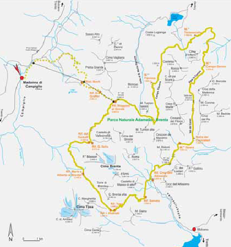

Brenta Dolomites tour

Trailhead: Madonna di Campiglio (1514 m, regular bus connections to Trento)
Highest point: Bocca di Brenta (2552 m)
Total travelling time:21,5-23 h
Overall height gain/loss: +3386 m - 2458 m (with descent to Madonna di Campigli, 3386 m)
Alp Convention

Route descriptions: The Dolomites of Brenta are one of the most fascinating ranges of the entire alpine area. This magnificent massif, with its sharp cliffs and rocky towers, is part of the Dolomites, even though it is located on the western side of Adige and therefore quite distant from the rest of the range. In 1967 the entire group, that is Adamello, Presanella and Brenta, became part of the Natural Park covering an area of 620 km². This region offers not only a signifi cant variety of animal and plant species and over fifty lakes, but the Park is also the brown bear’s natural habitat. Thanks to their uniqueness and beauty, on 26th June 2009, the Dolomites became a UNESCO World Heritage site. Since alpinism began, the Brenta has always attracted many climbers. Up to a few years ago, it seemed impossible for trekkers to venture on its peaks and enjoy its beautiful rocky landscape to the full. A good network of huts makes possible to spend more than a few days on the Brenta. This brochure describes a three day tour (it is possible to extend it 2 more days) which takes you to the heart of the range, amongst the 800 m rock towers. The superb view of the Presanella, Adamello and Ortles group will make this experience truly unforgettable. Furthermore there are other possible tours, both for experienced trekkers (Dolomiti di Brenta Trek Expert) and for less experienced (Dolomiti di Brenta Country).

Skills required:The majority of tours around Brenta include a via ferrata. In this tour, the via ferrata is avoided, nevertheless you still need to use very careful and confident footwork and have a head for heights. The massif presents abrupt slopes, sharp rock crests and slippery ground. Furthermore, during the summer, Brenta tends to get very heavy storms. Trekking and climbing is only possible during high pressure.

A tour through the wild and enchanting


Brenta Dolomites tour

Trailhead: Madonna di Campiglio (1514 m, regular bus connections to Trento)
Highest point: Bocca di Brenta (2552 m)
Total travelling time:21,5-23 h
Overall height gain/loss: +3386 m - 2458 m (with descent to Madonna di Campigli, 3386 m)
Alp Convention

Madonna di Campiglio – Campo Carlo Magno (loc. Fortini) – Rif. Stoppani al Grostè – Rif. Tuckett – Rif. Alberto e Maria ai Brentei – Rif. Pedrotti/Rif. Tosa


Travel time: 6-6,5 h.

In almost all itineraries, the ascent to the Stoppani al Grostè hut is achieved by cableway. However, this tour is designed for those who value the importance of doing things slowly so as to profoundly appreciate the surrounding and for this reason walking has priority. Naturally, if you prefer, you can also start this tour by cableway (open from the beginning of July to mid September, from 8.30 to 12.30 and from 14.00 to 17.00), shortening the fi rst day by 3½ hours. From the Stoppani al Grostè hut (2442 m) follow path 316 on the plateau and cross a vast boulder fi eld. The path takes you through meadows and gravel all the way to the Tuckett hut (2272 m). From the hut, follow path 328 walking on grasslands till the path forks at 2048 m, and you take path 318. Follow the steep cliff of Val Brenta, go through the short tunnel (Galleria Bogani) then walk up once more to the Maria e Alberto ai Brentei (2182 m) hut. Leave the hut and follow the signs of the alternative Expert route and walk up Campanile Basso following path 318 to “Bocca di Brenta” (2552 m). Here you reach the Pedrotti hut (2491 m) after a short descent or, slightly below, the Tosa hut (2439 m).

Accommodation:
Rif. Stoppani al Grostè (2442 m): Tel. +39-0465-440115, e-mail: [email protected], www.groste.it, open from mid June to the end of September, private.
Rif. Tuckett (2272 m): Tel. +39-0465-441226, e-mail: [email protected], open from mid/end of June to mid/end of September, SAT-CAI.
Rif. Maria e Alberto ai Brentei (2182 m): Tel. +39-0465-441244, open from mid/end of June to mid/end of September, SAT-CAI.
Rif. Pedrotti (2491 m): Tel. +39-0461-948115, e-mail: [email protected], open from mid/end of June to mid/end of September, SAT-CAI.
Rif. Tosa (2439 m): same as Rif. Pedrotti.

A tour through the wild and enchanting


Brenta Dolomites tour

Trailhead: Madonna di Campiglio (1514 m, regular bus connections to Trento)
Highest point: Bocca di Brenta (2552 m)
Total travelling time:21,5-23 h
Overall height gain/loss: +3386 m - 2458 m (with descent to Madonna di Campigli, 3386 m)
Alp Convention

Rif. Pedrotti/Rif. Tosa – Rif. Selvata – Passo del Clamer – Malga Spora – Sella del Montoz – Malga Campo Denno

Travel time: 8-8,5 h

From the Pedrotti hut (2491 m/Tosa hut 2439 m) descend to the Selvata hut (1630 m) and continue till the Croz dell’Altissimo hut (1431 m). Shortly before Croz dell’Altissimo, take path 44 to Pass del Clamer (2164 m). Walk across beautiful meadows and after a short descending slope, you reach Malga Spora (1851 m), which is run by the alpine club and here you can spend the night1. After Malga Cavedago (1848 m) take path 338 in the beautiful Val dei Cavai and reach Sella del Montoz (2327 m). After passing by Alpe la Campa you finally reach Malga Campo Denno (= Malga Campa; 1978 m) beneath the rocky walls of Croz della Madonna or Cimon di Campa.

Note: 1 If you stay overnight at Malga Spora you extend the trekking tour by one day, and you stay at Malga Flavona the next day (unwardened).

Accommodation:
Malga Spora (1851 m): Tel. +39-0461-653637, periodo di apertura: da inizio luglio a fine agosto, SAT-CAI.
Malga Campo Denno (1978 m): rifugio non gestito (sempre accessibile); materassi e coperte disponibili, privato.

A tour through the wild and enchanting


Brenta Dolomites tour

Trailhead: Madonna di Campiglio (1514 m, regular bus connections to Trento)
Highest point: Bocca di Brenta (2552 m)
Total travelling time:21,5-23 h
Overall height gain/loss: +3386 m - 2458 m (with descent to Madonna di Campigli, 3386 m)
Alp Convention

Malga Campo Denno – Malga Loverdina – Malga Termoncello – Malga Flavona – Rif. Stoppani al Grostè – Madonna di Campiglio/strong>

Travel time: 7,5-8 h (to Rif. Stoppani al Grostè) or 10-10,5 h (with descent to Madonna di Campiglio)

From Malga Campo Denno (1978 m) take the ascending path 370. The following descent heads north and crosses a zone of mugo pine trees all the way to Malga Loverdina (1771 m). After another short descent, take a road leading you to the alpine grazing of Termoncello (1856 m). After a few ups and downs and a stunning view of lake Lago di Tovel, take path 330 running along the magnificent highland of Campo Flavona, to reach Malga Flavona (1858 m). Walk up and head south till you take path 301. Walking amongst boulders you cross the Sella del Turion (saddle), follow path 301 till Passo del Grostè (2,442 m) and you fi nally reach the Stoppani al Grosté hut (2442 m). If you have enough time, you can end the tour by descending to Madonna di Campiglio on the same day. This will take an additional 2,5 hours. If your legs are tired and you have not got enough time, you can descend to the valley by cableway, spend the night at the Stoppani al Grostè hut, or descend to the G. Graffer hut (2261 m) and spend the night there.

Accommodation:
Malga Flavona (1858 m): unwardened hut (always open); mattresses and blankets available.
Rif. Stoppani al Grostè (2442 m): Tel. +39-0465-440115, e-mail: [email protected], www.groste.it, open from mid June to the end of September, private.
Rif. G. Graffer (2261 m): Tel. +39-0465-441358, e-mail: [email protected], www.graffer.com, open from mid June to mid/end of September, SAT-CAI.

A tour through the wild and enchanting


Brenta Dolomites tour

Trailhead: Madonna di Campiglio (1514 m, regular bus connections to Trento)
Highest point: Bocca di Brenta (2552 m)
Total travelling time:21,5-23 h
Overall height gain/loss: +3386 m - 2458 m (with descent to Madonna di Campigli, 3386 m)
Alp Convention

Useful information

Tourist information
APT Madonna di Campiglio: Tel. +39-0465-447501 e-mail: [email protected], www.campiglio.to
APT Terme di Comano - Dolomiti di Brenta: Tel. +39-0465-702626 e-mail: [email protected], www.comano.to
APT Dolomiti di Brenta: Tel. +39-0461-585836 e-mail: [email protected], www.esperienzatrentino.it
APT Val di Sole: Tel. +39-0463-901280 e-mail: [email protected], www.valdisole.net
Trentino S.p.A.: Tel. +39-0461-219500 e-mail: [email protected], www.trentino.to

Alpine Guides
Guide Alpine Adamello: Tel. +39-340-6142567 or +39-347-4574251 e-mail: [email protected]
Scuola di Alpinismo e Scialpinismo Madonna di Campiglio: Tel. & Fax +39-0465-442634 e-mail: [email protected], www.guidealpinecampiglio.it


Parks
Parco Naturale Adamello Brenta: Tel. +39-0465-806666 e-mail: [email protected], www.pnab.it

Weather
Province of Trento: www.meteotrentino.it
Province of Bolzano: www.provincia.bz.it/meteo
Italy: www.meteo.it, www.meteoitalia.it, www.meteoam.it

Maps
Alpenvereinskarte Sheet 51 (Brentagruppe): 1:25.000
Map Tabacco Sheet 10 (Dolomiti di Brenta „Adamello – Presanella – Val di Sole): 1:50.000 & 1:25.000
Map Freytag & Berndt-Wanderkarte WKS Sheet 17 (Brenta – Madonna di Campiglio – Presanella): 1:50.000

Alpine clubs
Società Alpinisti Tridentini (SAT), Sezione di Trento: Tel. +39-0461-981871 e-mail: [email protected], www.sat.tn.it
Società Alpinisti Tridentini (SAT), Sezione di Spormaggiore: Tel. +39-0461-653563 e-mail: [email protected]

Public transport
Trentino Trasporti: Tel. +39-0461-821000, www.ttspa.it
Integrated Transport in Alto Adige/Südtirol: Tel. +39-0471-450111 or 840 000471 www.sad.it

Websites
www.alparc.org
www.dolomitibrenta.it
www.dolomitibrentatrek.it
www.dolomitidibrentain.it
www.dolomitimolveno.com
whc.unesco.org/en/list/1237

  • BOOK YOUR TRIP
    Tell us your wants and needs and we will try to plan you the perfect trip

    BOOK

  • CONTACT US
    Please, write to us and ask us your questions, and we will get back to you.

    CONTACT US